Is Bahia, Brazil Safe for Tourists? (2026 Guide)
Jump to section
Updated April 2026: this guide uses the Anuário Brasileiro de Segurança Pública 2024 figures, current U.S. State Department advisory guidance, IBGE population data, Setur-BA tourism numbers, Numbeo city indices, and verified information about Bahia's tourist zones, transit corridors, and the gap between headline crime numbers and the routes travelers actually use.
Is Bahia safe? It's the most legitimately complicated answer in Brazilian travel writing, because Bahia is the state most often headlined as "the most violent in Brazil" and the state where millions of foreign visitors land each year and complete a holiday without incident. Both descriptions are true, and the only way they reconcile is geography. Bahia is larger than France, with a population of roughly 14 million distributed unevenly across a metropolitan capital, a 1,000-kilometer coastline of beach towns, a vast cattle-ranching interior, and a UNESCO-grade national park. The safety conversation has to be zone-specific. A blanket answer doesn't survive contact with how trips are actually planned.
Most English-language guides solve this by writing about Salvador only and pretending it's Bahia. That's tidy but misleading. A Bahia trip in 2026 typically means at least two of: Salvador, the Cocoa or Discovery Coast (Itacaré, Trancoso, Arraial d'Ajuda, Caraíva), Morro de São Paulo or Boipeba, and Chapada Diamantina. Each of those zones runs a different risk profile, and the headline numbers about peripheral Salvador violence don't transfer onto a beach town three hours south or a chapada town an hour-long flight inland.
For the country-level picture first, start with our Brazil safety guide. For the city-specific Salvador deep dive, our Salvador safety guide is the companion piece this article links to most often. The page you're reading right now is the state-level overview that ties them together.
Key Takeaways
- Bahia leads Brazil in absolute homicides — 4,480 in 2024 — but that count concentrates in peripheral districts and Recôncavo municipalities far from the routes tourists travel. The tourist-corridor experience runs much closer to São Paulo than to the headline number.
- Treat Bahia as four travel zones with distinct safety profiles: Salvador metro (mixed), the Cocoa & Discovery Coasts (low risk), the small islands and Morro de São Paulo (very low risk), and Chapada Diamantina (very low crime risk; wilderness caution applies).
- Stay in Barra, Ondina, Corredor da Vitória, or Rio Vermelho if you base in Salvador, fly between regions rather than taking long-distance buses on BR-101 or BR-242, and treat Pelourinho as a daytime-and-organized-evening district rather than a free-roam-after-midnight one.
Is Bahia, Brazil Safe for Tourists in 2026?
For most tourist itineraries, yes — with the caveat that Bahia rewards careful zone selection more than any other Brazilian state. The U.S. Embassy and Consulates in Brazil currently maintain Travel Advisory Level 2: Exercise Increased Caution for Brazil as a whole, with no elevated state-level restriction for Bahia (U.S. Embassy and Consulates in Brazil, 2026). The advisory is the same level as France, Spain, or the United Kingdom received in recent years.
The headline number is real and worth understanding. Bahia recorded 4,480 intentional homicides in 2024 — the highest absolute count of any Brazilian state, ahead of Rio de Janeiro (3,504), Pernambuco (3,381), and Ceará (3,272) (Anuário Brasileiro de Segurança Pública, 2024). That represents a state-level homicide rate near 30 per 100,000 inhabitants — well above the Brazilian national average of 17.9, which itself fell to a decade low in 2024 (Agência Brasil / FBSP, 2024).
The number that matters more for trip planning, though, is the geographic distribution. Police data and independent reporting consistently show that Bahia's homicide concentration sits in three specific clusters: peripheral districts of metropolitan Salvador (Subúrbio Ferroviário, parts of Cabula, Periperi), a handful of Recôncavo municipalities northwest of the capital (Camaçari, Lauro de Freitas peripheral zones, Feira de Santana periphery), and contested drug-route corridors in the cocoa-region interior. None of those overlap with the routes a tourist takes to reach Pelourinho, Itacaré, Trancoso, Morro de São Paulo, or Lençóis.
Numbeo's city-level index for Salvador still lists a high Crime Index and a Safety Index in the low-30s range (Numbeo, 2025). That index aggregates resident perception across the entire municipality — peripheral districts included — and reflects daily-life crime patterns more than tourist-corridor experience. Reading Numbeo as the tourist-corridor signal rather than as the city-wide signal it actually is is the most common mistake in Bahia trip planning.
The practical implication: tourists who pick the right zones, base themselves in the established tourist corridors, use app-based transport in the capital, and fly between regions tend to find Bahia much less complicated than the headline number suggests. Travelers who try to wing it across long-distance road segments at night, or who treat peripheral Salvador the way they'd treat midtown Manhattan, are the ones who end up with stories.
How Bahia's Safety Map Actually Works
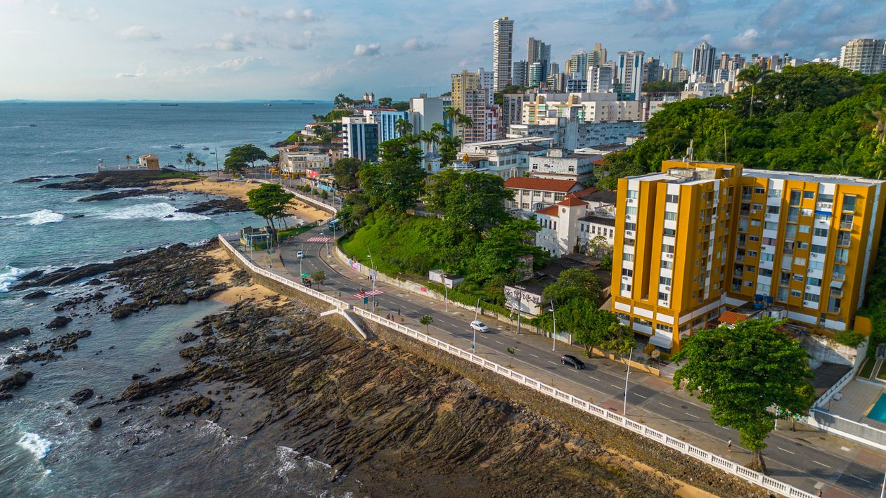
Bahia is the largest state in Brazil's Northeast — roughly 564,000 square kilometers, larger than France or California, with a coastline of about 1,000 kilometers (IBGE, 2024). The population sits near 14.1 million, with about 3.9 million concentrated in the metropolitan region of Salvador. That uneven distribution matters: Bahia's headline homicide count is a Salvador-metro story more than a state story. Once you leave Greater Salvador and the Recôncavo, the numbers thin out fast.
For trip planning, four travel zones cover almost every realistic Bahia itinerary:
Zone 1 — Salvador metro. Bimodal. The tourist corridor (Barra, Ondina, Corredor da Vitória, Rio Vermelho, Santo Antônio, parts of Pelourinho) is calm during the day and manageable at night with Uber. Peripheral districts and the Lower City beyond Mercado Modelo at night are the source of most of the state's homicide count and not where tourists end up.
Zone 2 — Cocoa Coast (Costa do Cacau). South of Salvador via flight or BR-101. Itacaré is the main hub, with Maraú peninsula, Camamu Bay, and Boipeba island in the same orbit. Low risk, sleepy beach-town pace, surf-tourism economy.
Zone 3 — Discovery Coast (Costa do Descobrimento). Further south, around Porto Seguro, Arraial d'Ajuda, Trancoso, Caraíva. International-resort tourism economy, low crime profile, the kind of trip that runs closer to a Caribbean holiday than to a Brazilian metro experience.
Zone 4 — Chapada Diamantina interior. Inland to Lençóis, Vale do Capão, Mucugê, Igatu. Among the safest parts of Brazil for tourists. The risk is wilderness — getting lost on a waterfall trail, dehydration, slips on wet rock — not crime.
Four zones, four risk profiles. The same FBSP state-level number means very different things in each one.
The state attracts roughly 16 million tourist visits per year — the second-highest in the Northeast after Pernambuco — across this geography (Setur-BA, 2024). The tourism economy is concentrated in exactly the zones above, and the policing presence reflects that. The Polícia Turística (DELTUR) operates a Pelourinho station, Setur-BA coordinates with the federal highway police on the Salvador–Itacaré–Porto Seguro corridor, and the Chapada national park has its own ranger structure. None of that is true for the peripheral districts.
Salvador Safety: Where to Stay, What to Avoid
Salvador is the only Bahia city where the safety conversation gets layered, and it deserves its own attention even inside a state guide. The short version: stay in the tourist corridor, treat Pelourinho as a daytime-and-organized-evening district, and use Uber after dark.
The reliable bases are Barra, Ondina, Corredor da Vitória, and Rio Vermelho. Barra is the default — the lighthouse area (Farol da Barra) anchors a walkable beach-and-restaurant strip with a heavy Polícia Militar presence, and most of Salvador's mid-range and four-star hotels sit between Barra and Ondina along Avenida Oceânica. Corredor da Vitória is the upscale residential option, useful if you want quiet evenings and short Ubers to dinner. Rio Vermelho is the bohemian, after-dark food-and-music neighborhood — moqueca restaurants, live music bars, casual nightlife — and works best for travelers willing to use Uber to and from rather than walk back at midnight.
Pelourinho is the single most important Salvador visit and the single most-misunderstood. The cobblestone old city, with its baroque churches, capoeira squares, and pastel facades, is a UNESCO World Heritage Site and one of the most photographed places in Brazil. Daytime Pelourinho is fine. The Tuesday night Bênção shows around Igreja de São Francisco and Largo Pedro Archanjo are a tourist institution and entirely manageable. Free-roam Pelourinho on a quiet Wednesday at 11 p.m. with a phone in your hand is a different conversation.
The areas to skip are clearly defined: peripheral districts (Subúrbio Ferroviário, parts of Cabula, Periperi, Itinga), the Lower City (Cidade Baixa) beyond the immediate Mercado Modelo / Elevador Lacerda zone after dark, and the unmarked side streets that branch off Praça da Sé into residential old-town blocks late at night. The Uber algorithm sometimes routes through neighborhoods on the edge of these areas to save five minutes; if it suggests a 25-minute route through unfamiliar peripheral districts to save time over the Avenida Paralela main route, take the longer main road instead.
For a deeper city-level walkthrough — best hotels, beaches, Carnival pattern, and detailed neighborhood-by-neighborhood breakdown — our Salvador safety guide is the companion piece. For the cross-Brazil scam patterns that translate into Bahia (drink spiking, motorcycle phone snatching, card-machine fraud at restaurants), our common scams in Brazil guide covers the specifics.

Is the Bahia Coast Safe?
Yes — the Cocoa Coast and the Discovery Coast run a much lower risk profile than the capital, and most of the famous beach destinations on a Bahia bucket list (Itacaré, Trancoso, Arraial d'Ajuda, Caraíva, Morro de São Paulo, Boipeba) are calm, walkable, and easy to navigate.
Itacaré sits on the Cocoa Coast, about a 90-minute flight from Salvador to Ilhéus and a ~70-kilometer transfer south. The town runs on surf and ecotourism — eight beaches connected by trail, family-run pousadas, açaí bowls, casual restaurants. It's safe with normal habits: don't leave valuables visible on the beach during peak season (December–February), use a beach-bag-with-a-zip rather than a tote, and walk the main street (Rua Pedro Longo / Pituba) freely at any hour. The forest trails between beaches are popular and considered safe in groups during daylight; solo hiking the longer connector trails (e.g., to Prainha) is best done with a guide.
Trancoso and Arraial d'Ajuda anchor the Discovery Coast (Costa do Descobrimento) south of Porto Seguro. Trancoso's Quadrado — the grass square ringed by colorful houses, with the chapel of São João Batista at one end — is one of the most photographed scenes in Brazil and operates as a closed, walkable village. The high-end resort economy keeps the area policed and watched. Arraial d'Ajuda runs slightly louder, with the Mucugê and Pitinga beach scenes and a livelier night strip; the same standard precautions apply. For more on Trancoso specifically, our Trancoso safety guide covers what to expect at the Quadrado and the surrounding beaches.
Caraíva and Boipeba are the more remote options. Caraíva is a sand-street village with no cars — boats and tractors only. Boipeba is a small island reached via boat from Cairu or Morro de São Paulo. Both are very safe, with the trade-off that medical evacuation in a serious emergency takes time. Travel insurance with repatriation coverage is the right call here.
Morro de São Paulo deserves its own paragraph because it's the single most-asked-about Bahia destination. The island is car-free, reached via two-hour catamarã from Salvador's Terminal Marítimo (Mercado Modelo area) or via overland transfer from Valença. The four numbered beaches (Primeira, Segunda, Terceira, Quarta Praia) range from village-busy to nearly empty, and the safety profile is among the lowest-risk in Brazil. The two situations to watch: phones and sandals at Segunda and Terceira Praias during the December–February peak (use a sealed dry bag and don't leave anything unattended), and the Tyrolean ferry / boat connection back from the island during stormy afternoons (book the morning catamarã, not the late-afternoon one, to avoid weather delays).
For Brazil-wide trip-insurance considerations — medical, evacuation, repatriation clauses — our travel insurance for Brazil guide covers what to verify before landing, and matters more on Bahia coast itineraries than on Salvador-only trips because of the island and remote-village factor.
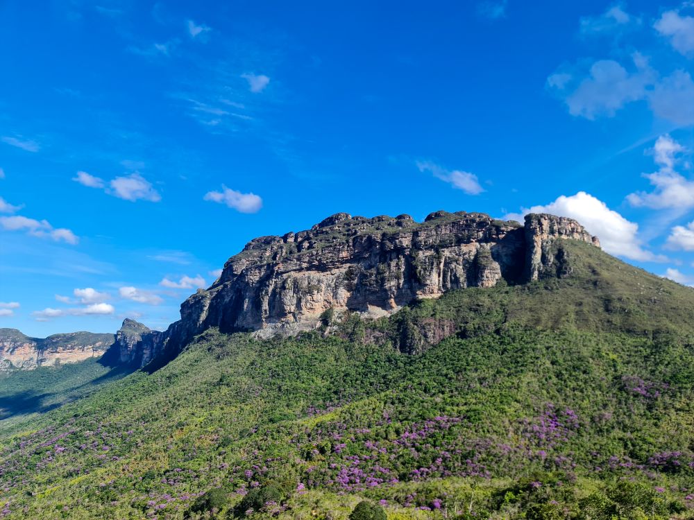
Is Chapada Diamantina Safe?
Yes. Chapada Diamantina is one of the safest parts of Brazil for tourists. The crime risk in Lençóis, Vale do Capão, Mucugê, and Igatu — the four towns that anchor most chapada itineraries — is genuinely close to zero in any practical tourist-experience sense. There are no peripheral districts that show up in regional homicide data, no urban-style scam patterns, and no theft-from-cars problem at the trailheads.
The risk profile in Chapada shifts from crime to wilderness. The waterfall trails — Cachoeira da Fumaça, Poço Encantado, Vale do Pati, Lapa Doce, Pratinha — are some of the most beautiful in Brazil and require respect. Hire licensed guides through the Associação de Condutores de Visitantes de Lençóis or your pousada; the local guides know which trails close after rain (slippery rock falls), which caves require dive-quality lighting, and which springs only hold their famous blue-light effect during specific midday windows. A reasonable rule: anything that requires more than ninety minutes of trail in either direction, hire a guide. The Vale do Pati multi-day trek absolutely requires one.
Lençóis is the gateway town. It has its own small airport (LEC) with daily Azul flights from Salvador (~50 minutes) and São Paulo (via Salvador). The flight is the recommended way in. The alternative is a six-to-seven-hour drive west on BR-242 from Salvador, which is fine in daylight but should not be done overnight; the federal highway police presence is good but the road runs through long stretches of flat scrubland with limited lighting and occasional mechanical-breakdown risk. Most agencies offer organized transfer-tour combos (Salvador → Lençóis with stops along the way), which split the risk and the driving across two professional drivers.
For broader regional pairings — Chapada Diamantina with the Bahia coast, with Iguaçu, with the Amazon — our Brazil travel destinations guide covers the full inter-regional logistics.
Transport Across Bahia: What You Need to Know
The single most consequential safety decision on a Bahia trip is the inter-regional transit choice. Bahia's geography means tourist routes can be 600 to 1,000 kilometers apart, and the difference between flying and bussing those segments is meaningful.
Air is the default for inter-regional travel. Salvador International (SSA) is the hub. From SSA you can connect to:
- Lençóis (LEC) for Chapada Diamantina — Azul, ~50 minutes
- Ilhéus (IOS) for Itacaré and the Cocoa Coast — Azul/Gol, ~1 hour
- Porto Seguro (BPS) for Trancoso, Arraial d'Ajuda, Caraíva — Azul/Gol/Latam, ~1 hour 15 minutes
Domestic flight prices in Brazil are reasonable (typically R$300–600 round-trip booked a few weeks in advance) and the safety upside is significant.
App-based transport handles intra-zone movement. Uber, 99, and InDrive operate in Salvador, Porto Seguro, Ilhéus, and most coast towns of meaningful size. In smaller villages (Caraíva, Morro de São Paulo, Boipeba), arrangements are pousada-coordinated by foot, beach buggy, or boat.
Long-distance buses are the segment to think hardest about. BR-101 (Salvador–Porto Seguro coastal route) and BR-116 (Salvador–Feira de Santana–interior) are the two main intercity bus corridors. Daytime travel is generally fine; overnight intercity buses are not the right call for a tourist itinerary. The BR-242 to Lençóis is the same — daytime only, organized transfer or your own rental car if you're confident driving Brazilian highways. For travelers who don't have driving experience in Brazil, flights or organized transfers are the right answer.
The Salvador airport transfer. SSA sits about 28 kilometers from Barra/Ondina and 32 from Pelourinho. Budget 25 to 45 minutes to Barra outside rush hour, longer during peak times. A typical Uber fare runs R$70–110 to the tourist corridor; the BRT (Linha Azul) airport bus is cheap (R$5) but slow and not the right call with luggage. The airport has a regulated app-pickup area on the upper level — use it rather than the curbside taxi touts inside the terminal.
The catamarã to Morro de São Paulo. Departures from the Terminal Marítimo Náutico da Bahia (next to the Mercado Modelo) run several times daily. Book through the operator (Biotur, Catamarã Gamboa do Morro) or through a hotel rather than from informal street agents at the terminal. The morning departures are smoother on the open Atlantic crossing than the late-afternoon ones.
For broader transport-and-insurance specifics, our travel insurance for Brazil guide covers the medical-evacuation coverage that matters most on remote-coast and chapada itineraries.
What to Do If Something Goes Wrong in Bahia
Start indoors. If anything happens — theft, a lost passport, a medical issue — move to a safe interior point: your hotel, a shopping mall, a Polícia Turística booth, or a regulated tourist-zone restaurant. In Salvador, Shopping da Bahia, Salvador Shopping, and the Shopping Barra are useful air-conditioned interiors with security staff, bathrooms, and Wi-Fi. In coast towns, the main pousada or hotel is the right first stop.
Emergency contacts for Bahia:
- 190 — Polícia Militar (Police)
- 192 — SAMU (Medical emergency)
- 193 — Bombeiros (Fire / rescue)
Salvador has a dedicated Delegacia de Atendimento ao Turista (DELTUR) station in the Pelourinho area that handles incidents involving international visitors specifically. It's a better first stop than a general police precinct if the issue isn't urgent. Outside Salvador, the main municipal precinct (Delegacia) handles tourist incidents. The Polícia Civil da Bahia also offers electronic boletim de ocorrência reporting through a Portuguese-language web portal — that's the document your travel insurance company will ask for, and most pousadas can help guests navigate the form.
The U.S. consular footprint in Bahia is light. There is a U.S. Consular Agency in Salvador (limited services, generally pass-through and emergency assistance) but no full consulate; the nearest full U.S. Consulate General for the Northeast is Recife. Knowing that routing before you land — rather than figuring it out during a lost-passport afternoon — saves hours.
Enroll in STEP (Smart Traveler Enrollment Program) before leaving the U.S. at step.state.gov. It's free, takes under 10 minutes, and gives the State Department a way to reach you in a genuine emergency. For the broader American-traveler frame, is Brazil safe for Americans covers consular support and the State Department advisory framework. For most tourists, the Brazil Safe Travel app also provides geolocation-based zone alerts (especially useful in Salvador's mixed urban geography), Portuguese audio for emergency reporting, and offline access to the right phone numbers — worth having installed before you arrive.
Frequently Asked Questions
Is Bahia state safer than Salvador?
Mostly yes — outside the Salvador metropolitan region, Bahia's coast and Chapada Diamantina interior run much lower risk profiles than the capital. The state's headline homicide count is heavily concentrated in peripheral districts of Salvador and a few Recôncavo municipalities. Beach towns like Itacaré, Trancoso, Caraíva, and the chapada gateway town Lençóis are reliably safe with standard urban habits.
What's the safest area to stay in Bahia?
For a Salvador base, Barra, Ondina, Corredor da Vitória, or Rio Vermelho. For a coast trip, Trancoso and the immediate Quadrado area, Itacaré's Pituba/Pedro Longo strip, or Morro de São Paulo's Segunda Praia. For Chapada Diamantina, central Lençóis or Vale do Capão village. All of these zones combine concentrated tourist services, regulated transport, and visible policing.
Is Morro de São Paulo safe?
Yes. The island is car-free, walkable, and runs one of the lower risk profiles in Brazil. The two practical cautions are not leaving phones or bags unattended on Segunda and Terceira Praias during the December–February peak season, and choosing the morning catamarã from Salvador over the late-afternoon one to avoid weather delays on the Atlantic crossing.
Is Chapada Diamantina safe for tourists?
Very safe from a crime standpoint — Lençóis, Vale do Capão, and Mucugê have negligible violent-crime profiles. The real risk in Chapada is wilderness: slips on wet rock, getting lost on long trails, dehydration on full-day hikes. Hire a licensed local guide for any waterfall route longer than 90 minutes one-way and respect the daytime-only rule on the BR-242 transfer from Salvador.
Is it safe to drive in Bahia?
Daytime intercity driving on the main coastal and chapada corridors (BR-101, BR-242) is generally fine for confident drivers familiar with Brazilian road conditions. Overnight long-distance driving is not recommended. For most tourists without Brazilian driving experience, flying between regions (Salvador to Lençóis, Salvador to Porto Seguro, Salvador to Ilhéus) is faster, safer, and only marginally more expensive than the bus option.
The Bottom Line on Bahia Safety
Bahia rewards travelers who treat it as a state of distinct zones rather than a single safety profile. The 4,480 absolute-homicides headline is real and worth knowing — Bahia leads Brazil in raw violent-death counts, driven by peripheral-district patterns most tourists never encounter. The tourist-corridor experience is a different number, closer to the Brazilian national average than to the state-level rate, and in zones like Chapada Diamantina or Trancoso, closer to a Mediterranean coast than to a Brazilian metro.
Pick your base carefully (Barra/Ondina/Rio Vermelho in Salvador; Trancoso, Itacaré, or Morro de São Paulo on the coast; Lençóis or Vale do Capão for the chapada). Fly between regions rather than bussing them. Use Uber after dark in the capital. Treat Pelourinho as a daytime-and-organized-evening district. That pattern handles a Bahia trip in 2026.
For the cross-Brazil habits that travel with you regardless of which Brazilian destination you're in, Brazil safety tips covers the pattern recognition that keeps the whole country — not just Bahia — manageable. For the timely "is now the moment to go?" question, is Brazil safe right now covers the current advisory and ground-truth picture for 2026.